
POLARIS NAVIGATION SYSTEM
DOWNLOAD: https://play.google.com/store/apps/details?id=com.discipleskies.android.polarisnavigation
Today's update to this versatile navigation application features an extended GPS satellite report, location/time based sunrise and sunset reporting and a new algorithm for our magnetic compass which increases responsiveness while masking magnetic noise.


Full Description:
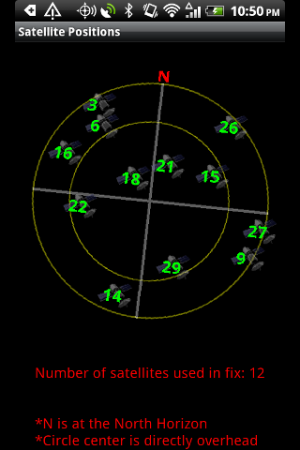
The Polaris Navigation System is a complete navigation package that includes reporting on all standard GPS parameters, an odometer, altimeter, speedometer and directional compasses. The GPS is backed by a robust waypoint management system for setting and locating your targets. Record trails and store them to a trail database. Trails can be viewed later or in real time on aerial or standard maps. A satellite reporting module shows the location of the GPS satellites relative to your position and graphs each satellite's signal strength. View waypoints, trails and your position on satellite and standard maps. Save maps for offline use with Google's Save-Maps-Offline feature. Our waypoint guidance system includes a dynamic waypoint-finding compass that will help you navigate to any saved waypoint with certainty while reporting estimated time of arrival, distance to target and other statistics. Turn-by-turn directions and route maps are included for navigating roads. While navigating, your data is backed up regularly meaning you will not lose your progress should your battery need replacement while en route to your destination. DS Software specializes in mobile navigation tools.
DOWNLOAD: https://play.google.com/store/apps/details?id=com.discipleskies.android.polarisnavigation
Attachments
Last edited:
 Twitter